

Dubai’s public transport network is about to gain its third rail line, and it’s arguably the most consequential one yet. The Blue Line will connect parts of the city that have never had direct metro access, tying together residential communities, industrial zones, and one of Dubai’s most ambitious waterfront developments. For residents, investors, and anyone tracking where Dubai is headed next, the Blue Line is a project to keep an eye on.
What Is the Dubai Metro Blue Line?
The Blue Line is the third rapid transit line on the Dubai Metro network, joining the Red Line and Green Line that have carried commuters since 2009 and 2011 respectively. It is being developed by Dubai’s Roads and Transport Authority (RTA), the government body responsible for the emirate’s roads, public transport, licensing, and traffic management.
Unlike the Red and Green Lines, which largely serve central and coastal Dubai, the Blue Line pushes east and southeast into districts that have historically depended on cars and buses. Until the Blue Line opens in 2029, buses will remain an important public transport option in many of these communities.
Our Guide to Dubai Bus Stations explains the city’s major stations, routes and intercity connections.It will run through Dubai Festival City, Dubai Creek Harbour, Ras Al Khor, International City, Dubai Silicon Oasis, Academic City, Mirdif, and Al Warqa, linking these growth corridors to the existing network for the first time.
The project was formally approved by His Highness Sheikh Mohammed bin Rashid Al Maktoum, Vice President and Prime Minister of the UAE and Ruler of Dubai, on 24 November 2023. The RTA subsequently awarded a construction contract worth roughly AED 20.5 billion to a consortium made up of Turkish firms MAPA and Limak alongside Chinese rail systems provider CRRC. Ground work began in April 2025, and the RTA has confirmed the line will begin operations on 9 September 2029, a date chosen deliberately, as it marks the 20th anniversary of the Dubai Metro’s original Red Line launch.
Once it opens, the Blue Line will stretch 30 kilometres, split between roughly 15.5 kilometres underground and 14.5 kilometres on elevated viaducts, making it the network’s most infrastructure-heavy line to date. The RTA has stated that construction is progressing in phases and that flood-mitigation measures have been built into the design following the flooding Dubai experienced in April 2024, with additional government funding directed toward the RTA and Dubai Municipality to safeguard the project’s most vulnerable sections.
Stations and Route Coverage of Dubai Metro blue Line
The Blue Line will feature 14 stations in total, comprising 9 elevated stations, 4 standard underground stations, and 1 underground interchange station:
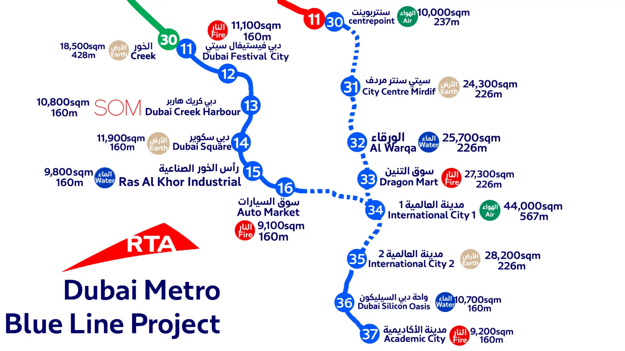
By Jad Krimeed – Own work, CC0, Link
- Creek Station: Interchange with the Green Line in Al Jaddaf (Elevated)
- Dubai Festival City Station: Serving the retail and waterfront district (Elevated)
- Dubai Creek Harbour Station: The line’s architectural centrepiece, designed by Skidmore, Owings & Merrill (SOM), standing roughly 74 metres tall and expected to be among the tallest metro stations in the world (Elevated)
- Ras Al Khor Station: Covering the industrial area and the adjacent wildlife sanctuary (Elevated)
- International City 1 Station – The major underground Y-junction interchange linking both branches of the Blue Line (Underground)
- International City 2 and 3 Stations: Serving the residential and commercial pockets of the community (Underground)
- Dubai Silicon Oasis Station: Positioned near Fakeeh University Hospital in the technology hub (Underground)
- Academic City Station: Terminus for Branch A, serving Dubai’s university district (Elevated)
- Mirdif Station : Serving the residential district close to City Centre Mirdif (Elevated)
- Al Warqa Station : Serving the residential district and nearby Dubai Safari Park (Elevated)
- Centrepoint Station – Terminus for Branch B and interchange with the Red Line in Rashidiya (Elevated)
The line operates via two main interconnected routes that converge at the International City 1 interchange:
- Branch A (21 km): Connects Creek Station (Green Line) to Academic City via Dubai Creek Harbour, Ras Al Khor, International City, and Dubai Silicon Oasis.
- Branch B (9 km): Connects Centrepoint Station (Red Line) directly to International City 1 via Mirdif and Al Warqa.
One of the most striking engineering features is a 1,300-metre bridge carrying the line across Dubai Creek, marking the first time the metro network has crossed the waterway on an elevated structure of this scale.
According to the RTA, the completed line is projected to serve close to one million residents living along its corridor by 2040, with daily ridership expected to reach around 200,000 passengers by 2030 and more than 320,000 beyond 2040. Trains are designed to run roughly every two minutes at peak capacity, moving up to 46,000 passengers per hour in each direction.
Traffic, Daily Life and the Dubai metro Blue line
Beyond the engineering, the RTA has framed the Blue Line as central to Dubai’s 2040 Urban Master Plan and its “20-minute city” ambition, where residents can reach most essential services within a short commute rather than relying on long car journeys. RTA officials have indicated the line could reduce road congestion by around 20 percent in the nine districts it passes through, cutting typical travel times across these neighbourhoods to somewhere between 10 and 25 minutes. The authority has also estimated the project will generate tens of billions of dirhams in broader economic, social, and environmental value by 2040 through time savings, lower fuel consumption, reduced emissions, and fewer road accidents.
Day-to-day convenience will also improve well before trains start running, since anyone living or working near the new corridor already has access to the RTA’s wider digital service network. RTA smart kiosks, first rolled out in 2018 and upgraded in 2021, are self-service touchscreen terminals placed at metro stations, malls, and government offices across Dubai.
They currently offer around 28 digital services covering Nol card top-ups and replacements, vehicle registration renewal, driving licence renewal, parking permits, and traffic fine payments, with support for cash, card, and NFC payments plus multilingual and accessibility features like height-adjustable screens and voice guidance.
The original rollout placed 50 kiosks across 23 metro stations, and while the network has since been consolidated into fewer, more capable machines at around 21 key locations, it remains closely tied to metro stations specifically, since that’s where footfall is highest.
Every new Blue Line station is a natural candidate for this kind of self-service access once it opens, letting commuters top up their Nol card or handle an RTA errand on the same trip rather than making a separate visit.
Property Prices Along the Dubai Metro Blue Line
For anyone watching Dubai’s real estate market, the Blue Line is more than a transport upgrade it’s a catalyst. The RTA has stated that property and land values near the new stations could rise by as much as 25 percent, Buyers interested in the long-term impact of improved transport connectivity can also explore apartments for sale in Dubai and compare properties across communities with existing and planned Metro access. a pattern consistent with what happened around Red and Green Line stations after they opened. Districts expected to benefit most include International City, Dubai Silicon Oasis, Ras Al Khor, Mirdif, and Al Warqa, all of which currently lack direct metro access and rely heavily on private vehicles or bus routes.
This kind of uplift tends to unfold in stages. Early movement typically comes from investors positioning ahead of construction milestones, followed by a second wave of demand as stations near completion and commute times become tangible rather than theoretical. Rental demand in these areas is also expected to climb, particularly from tenants who currently work in central Dubai but have been priced out of areas closer to the existing Red and Green Lines. Tenants considering these communities can compare apartments for rent in Dubai to see how current options near the future Blue Line corridor compare with other parts of the city.
If you’re comparing apartments for rent in International City, Dubai Silicon Oasis, Mirdif, or Al Warqa, it helps to know where rents currently stand before the Blue Line effect kicks in:
- International City remains one of Dubai’s more budget-friendly districts, with average annual rents for apartments currently sitting around AED 61,000, and listings ranging from roughly AED 27,000 for compact studios up to AED 229,000 for larger units. It’s a popular choice for multicultural, close-knit community living, and its Central Business District cluster sits close to where International City 1, 2, and 3 stations are planned.
- Dubai Silicon Oasis currently sees one-bedroom apartments renting from around AED 52,000 to AED 65,000 a year, with studios starting closer to AED 45,000. As a mixed residential-and-business free zone with its own schools, retail, and healthcare, DSO is expected to benefit strongly from having its own dedicated station rather than relying on nearby bus feeders.
- Mirdif already commands higher rents than International City or DSO thanks to its established villa-and-apartment mix and proximity to City Centre Mirdif, but it has never had direct metro access, something the new Mirdif Station is set to change.
- Al Warqa is a quieter, largely residential pocket bordering Dubai Safari Park, and like Mirdif, its upcoming station will be its first direct tie-in to the metro network.
None of these figures reflect a “Blue Line premium” yet, since the line is still years from opening. But they give a useful baseline for comparing how rents move as construction milestones are hit between now and 2029.
It’s worth being realistic about timing, though. The line won’t open until September 2029, and property markets rarely move in a straight line: factors like broader economic conditions, supply in each district, and the pace of construction milestones will all shape how quickly any uplift materialises.
Future Expansion Plans
The Blue Line is part of a larger expansion of Dubai’s rail network. Once it opens, the RTA has said the combined metro and tram system will grow from 101 kilometres to 131 kilometres, and the total station count across the network will rise from 64 to 78 stations. The Blue Line will also connect to the wider Etihad Rail network, Dubai’s line, an aspect that adds a national rail dimension to what has so far been a purely city-level system.
Beyond these figures, the RTA has not published detailed public plans for a Blue Line extension or a fourth metro line, so any speculation on further expansions beyond what’s outlined above should be treated as unconfirmed until the RTA makes a formal announcement.
Frequently Asked Questions About Dubai Metro Blue Line
When will the Dubai Metro Blue Line open?
The RTA has confirmed operations will begin on 9 September 2029, timed to mark the 20th anniversary of the Dubai Metro’s Red Line.
Who is building the Blue Line, and how much does it cost?
The Roads and Transport Authority (RTA) is developing the project, with construction awarded to a consortium of MAPA and Limak (Turkey) and CRRC (China) under a contract worth roughly AED 20.5 billion.
How many stations will the Blue Line have?
Fourteen stations in total, including two interchange points: Creek Station with the Green Line and Centrepoint Station with the Red Line, plus the Y-junction interchange at International City 1.
Which areas will the Blue Line serve?
Dubai Festival City, Dubai Creek Harbour, Ras Al Khor, International City (three stations), Dubai Silicon Oasis, Academic City, Mirdif, and Al Warqa, alongside its two existing-network interchanges at Creek and Centrepoint.
How long is the Blue Line, and how much of it is underground?
The full route runs 30 kilometres, made up of roughly 15.5 kilometres underground and 14.5 kilometres on elevated viaducts across two connecting branches (Branch A: 21 km, Branch B: 9 km).
Will the Blue Line affect property prices near its stations?
The RTA has said land and property values near Blue Line stations could rise by up to 25 percent, based on patterns seen around existing Red and Green Line stations. Areas with high potential for property price hikes include International City, Dubai Silicon Oasis, Ras Al Khor, Mirdif, and Al Warqa.
Is the Blue Line map or route already on Google Maps or the RTA app?
Not yet as a live transit line. The RTA released the official route map in December 2025, but it will only be added to Google Maps, the RTA app, and station signage once the line opens in September 2029.
Are there confirmed plans to extend the Blue Line further after it opens?
The RTA hasn’t published details of a Blue Line extension or a fourth metro line beyond the current 14-station route, so this should be treated as unconfirmed until an official announcement is made.
Will there be RTA smart kiosks at the new Blue Line stations?
The RTA hasn’t issued a station-by-station confirmation yet, but its smart kiosk network has historically been concentrated at metro stations, so new Blue Line stops are a reasonable candidate for future rollout once the line is operational.




Leave a Reply